




THE CONVERSATION – After the United Nations adopted a resolution in September 2026 endorsing a map that more fairly represents the size of Earth’s landmasses, author and journalist Moky Makura of Africa No Filter – a main sponsor of the Correct the Map initiative – asked: “What else about Africa is the world underestimating that’s also hidden in plain sight?”
It is a fair question.
The initiative brought attention to the way continents are distorted by projections that display our rotund planet on two-dimensional maps, something that has long made Africa especially appear far smaller than it actually is. But it left another assumption untouched: that European maps of Africa – which became the basis of how we see African countries today – are based solely on the observations of the Europeans who made them.
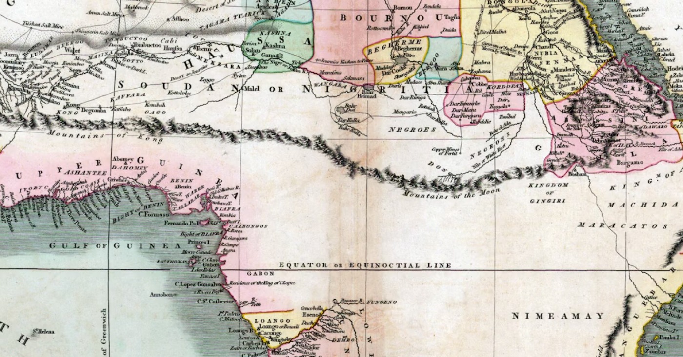
As an expert on the map history of Africa, I know that this is a misconception which deserves rethinking. Recent research by myself and others on colonial-era mapping of West Africa demonstrates that much of the geographical information these maps show is based on African observations. It’s just that Europeans largely took the credit.
A line in the sand
Most African map traditions are undocumented or ephemeral. But ground and oral mapping was common in the pre-colonial period, and often highly valued. European explorers relied upon these indigenous mapping practices during their travels and sometimes incorporated them into their own maps.
For example, sections of French explorer Henri Duveyrier’s 1861 map of the Sahara owed much to the maps drawn in the sand by his guide, Cheikh-‘Othmàn. Indeed, more than a third of Duveyrier’s map is based on information provided by local sources.
A common objective of mapping is to solve a spatial problem. Route mapping is all about finding one’s way between points A and B and determining the distances between them. For Europeans, it was important to know where African leaders resided or the most direct route to important trade centers.
When European explorers and soldier-surveyors inquired, African guides, interpreters and merchants described the road ahead and often drew these routes on the ground with a stick. Europeans valued African oral and ground-mapping practices for their contributions to knowledge; they were also useful for empire building.
In his 1892 travel memoir, French Navy Lt. Louis-Gustave Binger reproduced the plan of Niellé, a city in contemporary northern Ivory Coast that was drawn on the ground by his interpreter, Fofana Diawé.
Niellé’s chief prohibited Binger from visiting the town, making Diawé’s drawing particularly valuable. In another instance, Binger reports that an African intermediary placed varied lengths of straw on the ground to indicate the distances between localities in the Kong region.
In his exploration of the area between the Niger River and the Gulf of Guinea in the early 1890s, Navy Lt. Jean-Baptiste Marchand routinely collected route information from local inhabitants about places he could not visit. This “locally sourced route information,” as he described it, appears as dashed lines on his landmark map of the region. The routes of Marchand and other European explorers appear as solid lines.
When the total distance of all routes is calculated, African sources account for 65% of routes on Marchand’s map.
Thanks to African intermediaries guiding these military explorers, Binger discovered that the fabled Kong Mountains, which stretched across most 19th-century maps, did not exist.
And Marchand learned that the savanna penetrated more deeply into the rainforest in south-central Ivory Coast. The elimination of the imaginary Kong Mountains and knowledge of a shorter travel distance through the dense tropical forest accelerated French colonization of the region.
But this practice of displaying locally sourced route information on European maps was debated among European geographers and military officers. Some mapmakers refused to display African mapping because it did not follow the standards of scientific cartography.
They argued that the geographical information was based on hearsay rather than measurement. Others, particularly military officers trying to expand colonial boundaries, appreciated locally made maps’ practical value. Embedded in this debate was the self-claimed civilizing mission ideology underpinning colonialism, which assumed the superiority of European knowledge. The dashed lines suggest that locally sourced information was tentative and would eventually be replaced by solid lines based on European measurements.
Filling in the blanks
The appearance of blank spaces on maps is typically seen as demonstrating the scientific standard of accuracy: Cartographers don’t show what we don’t know.
Blank spaces were also viewed as instrumental to imperial expansion. That’s because they suggested vacant areas open to colonization.
The common denominator of both views is that Europeans determine what is shown and not shown on maps of Africa. But a closer look at explorers’ and soldier-surveyors’ reports indicates that blank spaces often emerged from the refusal of African authorities to allow Europeans to travel through their territory.
Wisely, these African rulers understood the ultimate goals of European soldier-surveyors – to map the road to colonial conquest. In the memoir of his exploration of contemporary Mali, Ivory Coast and Burkina Faso, Binger explained the blank spaces on his four-sheet map as deriving from his lack of “a good guide and a travel permit [from African authorities].”
To try to overcome this lack of access, colonial officials employed Africans to explore and map. Traces of their little-known expeditions appear in late 19th- and early 20th-century compilation maps assembled by European mapmakers. The travel routes of two Senegalese explorers, Roger Panet in 1850 and Bou El Mogdad Seck around a decade later, appear in Hermann Habenicht’s ten-sheet map of Africa published in 1885-1886.
The central Africa mapping of two Africans working as Portuguese trade agents, Pedro Joao Baptista and Amaro José, is depicted on the “Kabébé” sheet of Régnauld de Lannoy de Bissy’s 63-sheet map of Africa.
The display of their itineraries in solid lines alongside those of Europeans indicates their equal treatment by Lannoy. Lannoy also used the dashed-line symbol to show locally sourced geographical information. More than two-thirds of the route information displayed in his 1882 Segou-Sikoro sheet stems from African mapping practices.
Both maps were used at the Berlin Africa Conference of 1884-85 to determine the boundaries of free trade zones in the Congo and Niger river basins.
The conference kick-started the “scramble for Africa” that was to last into the 20th century. Paradoxically, the maps that Africans helped construct were later used to divide their territories into European colonies.
Decades after decolonization, when we open the drawers of national archives, we find these remarkable maps with their solid and dashed lines. And map historians are finally acknowledging that these maps, cataloged as purely European achievements, are in fact hybrid productions that emerged from complex intercultural encounters. The evidence was hidden in plain sight.
Based on reporting by The Carolinian.